Victorian Bushfire disaster - a Satellite's eye view
|
||
| 09 Feb 2009 | ||
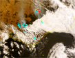 |
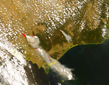
Pictured left are images received by the ES&S Satrax-700 satellite ground-station of the bushfires from this past weekend. The red dots on the first image from Saturday (click to enlarge) are automatically created by the system's processing software when high temperature anomalies are detected. These "hot-spots" are used to detect fires in remote areas each time a satellite passes over the area, day or night.
|
|